
Background
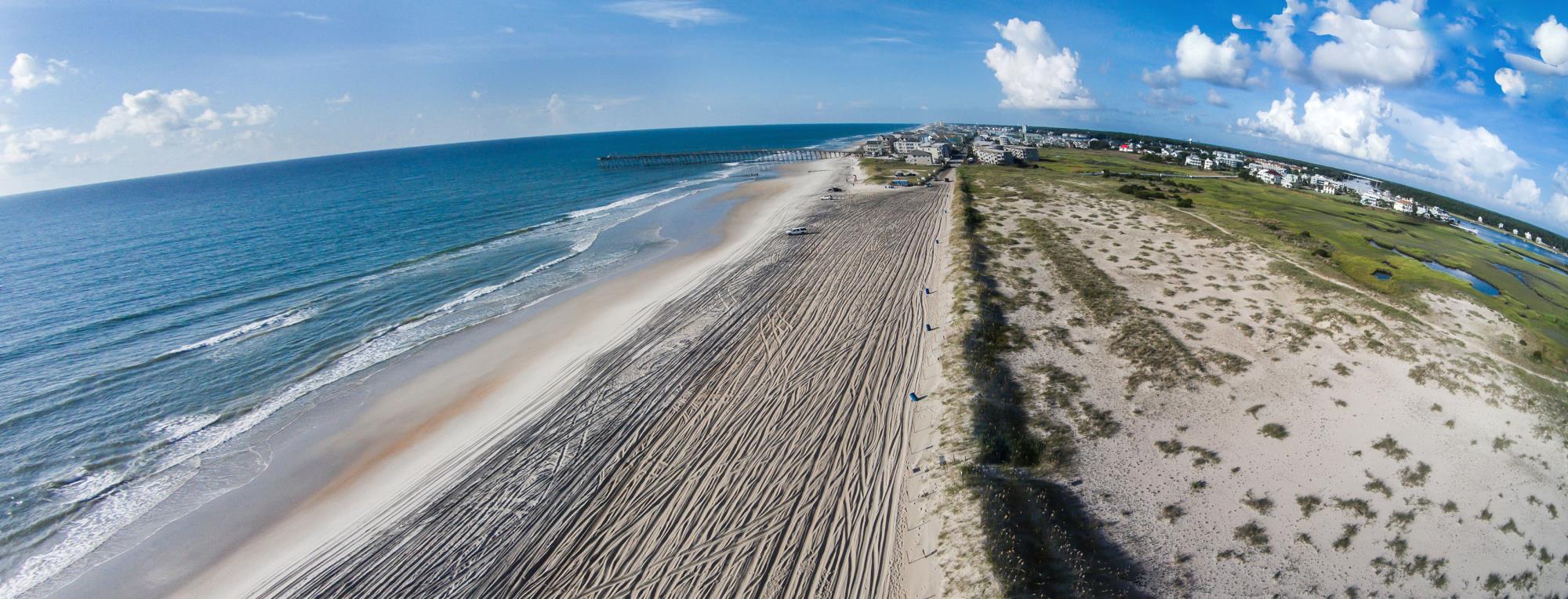
Carolina Beach is a dynamic barrier-island community on North Carolina’s southern coast, where vibrant tourism, long-standing neighborhoods, and natural systems converge along a narrow and ever-changing shoreline. Bordered by the Atlantic Ocean and the Cape Fear River, the Town faces both acute storm-related risks and chronic challenges associated with sea level rise, tidal flooding, and shoreline change.
Recent data highlight the extent of these issues: sensors in Carolina Beach recorded flooding on more than 65 days in a single year, far exceeding the frequency traditionally expected outside of storm events (NC State News, StarNews Online). Meanwhile, the Town continues to implement beach renourishment and dune maintenance programs to combat ongoing erosion and sand loss (Spectrum Local News).
Key Risk Factors
Carolina Beach experiences flooding and erosion pressures from multiple directions and sources:
- Tidal inundation and king tides that flood streets and low-lying yards even on calm days.
- Storm surge and wave overwash during hurricanes and nor’easters, which erode dunes and damage oceanfront properties.
- Heavy rainfall and stormwater flooding overwhelm drainage infrastructure in developed areas.
- Localized flooding around Carolina Lake, where limited drainage capacity and elevated groundwater levels cause repeated ponding along surrounding roads and properties during rain and high tide events.
- Flooding of canals and back-barrier neighborhoods, particularly during high tides or blocked outfalls, which can cause water to back up into yards, driveways, and roadways.
Natural systems such as beaches, dunes and wetlands help buffer wave energy and provide ecological value, but these areas are increasingly stressed by recurrent flooding and sea level rise.
RCCP Program Overview
The Resilient Coastal Communities Program (RCCP), administered by the North Carolina Division of Coastal Management (DCM), helps coastal towns plan for and adapt to the increasing impacts of flooding, storms, and sea level rise. The program provides funding and technical support to guide communities through a structured, four-phase process that moves from understanding vulnerabilities to implementing resilience projects.
Carolina Beach is currently participating in Phases 1 and 2, which focus on assessing local risks and identifying practical, community-supported strategies to improve resilience.
Phase 1 – Risk and Vulnerability Assessment
During Phase 1, the project team will collect and analyze existing studies, maps, and data to better understand how Carolina Beach is affected by flooding, erosion, and other coastal hazards. The team will:
- Evaluate exposure and sensitivity of critical assets, natural systems, and infrastructure.
- Identify priority areas most vulnerable to coastal hazards.
- Engage residents and local stakeholders to incorporate community knowledge and experience into the assessment.
The outcome of Phase 1 will be a clearer picture of where and how the Town is most at risk — and where resilience efforts can make the biggest difference.
Phase 2 – Planning and Project Identification
Building on the findings from Phase 1, Phase 2 focuses on developing a Resilience Project Portfolio — a prioritized list of strategies and projects that address the Town’s highest needs. These may include a combination of structural, non-structural, and nature-based solutions that protect people, property, and natural resources.
Key activities in Phase 2 include:
- Identifying a range of potential resilience and adaptation solutions.
- Ranking and prioritizing projects based on community benefit, feasibility, and funding potential.
- Coordinating recommendations with ongoing stormwater management, shoreline protection, and Town planning initiatives.
The final output of Phase 2 will be a ranked portfolio of high-priority projects ready for preliminary design and funding pursuit in Phase 3.
Community Engagement Plan
Community engagement is central to the RCCP process. Carolina Beach has established a Community Action Team (CAT) composed of residents, business owners, and civic representatives to help guide project development and ensure that local priorities are reflected in the Town’s Resilience Strategy.
The CAT serves as the local voice of this project, helping ensure the planning process captures real experiences and community values. Members bring important local insight into flooding, erosion, drainage, and infrastructure challenges while helping to shape future adaptation strategies for the Town.
CAT members play a key role throughout the RCCP process by serving as the local voice of the project—ensuring the plan reflects community priorities and lived experiences. They share knowledge about local flooding, erosion, and infrastructure issues; help identify what’s most important to protect, such as homes, roads, natural areas, and community spaces; and review maps and data to verify that they accurately reflect on-the-ground conditions. The CAT also provides input on proposed resilience and adaptation strategies, builds consensus among residents and partners on the best path forward, and helps shape the final Resilience Strategy and Project Portfolio so it is realistic, community-supported, and fundable.
Community Action Team (CAT) Members
- Stephen Taylor
- Joseph Starks
- Matthew Lettrich
- Stefanie Young
- Debi Haynes
Beyond the CAT, there will be multiple opportunities for the public to get involved throughout the RCCP process.
Public Involvement
- CAT Meetings – providing direction, feedback, and local knowledge at key project milestones.
- Interactive Project Website (hosted on Social Pinpoint) – featuring maps, surveys, and draft materials for public review and comment.
- Community Events – outreach opportunities such as the Carolina Beach Drone Show (November 7) and Christmas Parade (December 5) to share information and gather input on resilience planning.
Together, these activities will ensure that the Carolina Beach RCCP planning process is guided by the people who know the community best—its residents.


